|
Home |
Search the Database |
Display Index |
Contact Us |
Database Login
|
The national database of state and local wildfire hazard mitigation programs
serves as a clearinghouse of information about nonfederal policies and
programs that seek to reduce the risk of loss of life and property through
the reduction of hazardous fuels on private lands. If
you would like to submit a program to the national wildfire programs database,
please complete the following form (MS
Word).
Return to your search results or Perform a new search
|
Title: |
Colorado Springs, CO - Firewise Website Features Home Risk Assessments
|
|
Type: |
Education
Designation of high risk areas
Demonstration projects
Community Planning
|
|
Jurisdiction: |
City/town
|
|
State: |
Colorado
|
|
Program Description: |
Colorado Springs Fire Department � FireWise Program
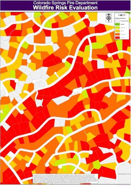
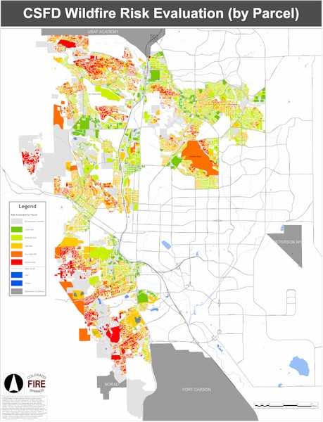
The Wildland Urban Interface in the city of Colorado Springs is quite large, encompassing 45 square miles, and more than 35,000 residential parcels. The Colorado Springs Fire Department (CSFD) has done an award-winning job in creating a FireWise program for the city's wildland-urban interface. Every parcel in the interface has been evaluated and assigned an individual wildfire hazard rating. Homeowner education includes an interactive FireWise website which features a map showing hazard ratings by parcel, landscaping demonstration areas, and on-site vegetation management consultations.
On April 22 2003, the Colorado Springs Fire Department's Wildland Risk Management Office was presented with the David Ball Award for Fire and the Environment, sponsored by Kidde, and presented at the US Environmental Protection Agency�s Climate Protection Awards Dinner.
Wildfire Mitigation Plan and WHINFOE Model
In 2000, The Colorado Springs Fire Department published its study of wildfire hazard risk in the WUI areas. The Plan used the WHINFOE (Wildfire Hazard Information Extraction) Model to assign five levels (Low, Moderate, High, Very High and Extreme) of wildfire hazard risk ratings for parcels in the city's wildland urban interface. The WHINFOE model looks at twenty-five weighted factors, which determine the rating. Data collected includes:
- Construction materials and design;
- Topography;
- Fuel types;
- Vegetation Density;
- Defensible Space;
- Ingress and egress;
- Aspect.
Using GIS, maps of the interface were constructed to show Background Fuel Types � (urban, short grass, long grass, brush, timber, mature timber), Elevation, Slope, Aspect, Fire Behavior Index � (computer model of dangers from crown fire and spotting), Structure Density, and the Areas of Concern (a compilation of factors from the above maps).
Parcel level information used in assigning hazard ratings was collected during 2000 using CSFD's nine interface fire stations. Over a period of six months site visits were made to each residential address to collect six data inputs including address visibility, dangerous topography, roof types, siding material, defensible space and vegetation density.
Firewise Website
The Colorado Springs Fire Department has created a unique website for Firewise Information. A short three-minute online video explains FireWise concepts to the user, and explains how to use the website. The website allows users to click on any property in the WUI area and see both its wildfire hazard, and its underlying scores. By clicking on �Improve Your Hazard Rating�, the user is presented with information on defensible space, ladder fuels, and pictures of well-managed and unmanaged vegetation, along with details on the city's Class A roofing ordinance (January 2003) which requires all new roofs and repairs greater than 25% to use Class A roofing material. Once a homeowner has taken steps to improve their rating, they can call the Fire Department's FireWise Office and request a new evaluation.
Firewise Demonstration Area
During Fall 2003, the Colorado Springs Fire Department developed two Firewise Demonstration Areas. Each is located in high-risk areas and demonstrates good vegetation management concepts and communicates to homeowners that Firewise landscaping does not mean clear-cutting. The sites have received both compliments and a lot of interest from area homeowners. The CSFD hopes to strategically locate additional demonstration sites in high-risk neighborhoods, and is working with several homeowners associations on stewardship agreements.
Contact Information
For more information, contact Chris Barth, Firewise Program Coordinator, at 719-385-7281, or by email at [email protected].
|
|
Images: |
|
1. | 
|
|
|
|
2. | 
|
|
|
|
|


