|
Home |
Search the Database |
Display Index |
Contact Us |
Database Login
|
The national database of state and local wildfire hazard mitigation programs
serves as a clearinghouse of information about nonfederal policies and
programs that seek to reduce the risk of loss of life and property through
the reduction of hazardous fuels on private lands. If
you would like to submit a program to the national wildfire programs database,
please complete the following form (MS
Word).
Return to your search results or Perform a new search
|
Title: |
La Plata County, CO -- Wildfire Hazard Assessment and Map/ A BEHAVE model
|
|
Type: |
Designation of high risk areas
|
|
Jurisdiction: |
County
|
|
State: |
Colorado
|
|
Program Description: |
La Plata County, Colorado - Wildfire Assessment And Map: A Behave Model.
Predicting Fire Behavior
La Plata County, Colorado was hit hard by the Missionary Ridge fire, which burned 73,000 acres and consumed 56 homes during the summer of 2002. Just one year before the fire, in 2001, a group of scientists led by Dr. Bill Romme of Colorado State University, produced a study of wildfire risk for La Plata County using the Behave Fire Model. The objective of the study was to assess the hazard of wildfire within the county, and identify the areas of highest risk showing them spatially in map form.
The Missionary Ridge fire occurred in a period following a long drought, with very windy days, single digit humidity, and in an area of lots of fuels. The fire did burn intensely in many of the places where the model predicted the potential for that kind of fire behavior, and it threatened homes in some of the places that had been identified as high fire hazard, such as around the Vallecito Reservoir. The fire proved to be an unexpected validation of the model.
Methodology
Fire hazard, as it is used in the study, is the probability of extreme and damaging fire behavior under severe fire weather conditions. Three key parameters of fire behavior were used for the study: total potential heat release, rate of fire spread and flame length.
All mapping was done using GIS, primarily using ESRI ArcView 3.2a software with Spatial Analyst extension. All datasets were co-registered to the Universal Transverse Mercator Projection, NAD27, zone 13. The base map was created using vegetation maps of the county, and topographic maps from the USGS. The vegetation and topography data layers were combined to produce a raster base map of vegetation/slope units for the county. Each vegetation type was assigned a fuel model type, and then fire behavior under severe weather conditions was simulated for each fuel model using Behave. Output from Behave was adjusted to reflect the effects of aspect, and the resulting values from the Behave simulations were assigned to each pixel in the vegetation/slope data layer to produce a map of expected fire behavior under severe weather conditions. Researchers overlaid a map of built parcels from the La Plata Planning Department, to show how wildfire hazard threatens existing communities and individual homesites.
Results of the Study
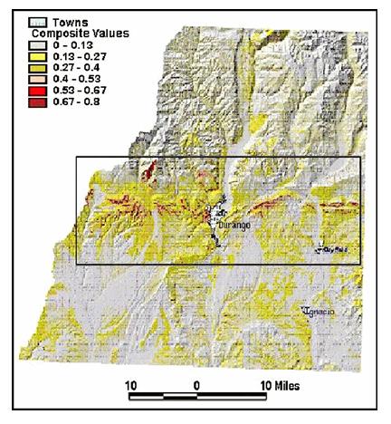
The resulting maps are of Simulated Heat Release, Simulated Flame Length, and Simulated Spread Rates, with Residential Development shown on each map. The Simulated Heat Release Map shows that heat release values tend to be especially high in the central portion of La Plata County where exurban development is most concentrated. The Simulated Flame Length Map shows areas of concern primarily in the southern and central portions of the county, including the area where exurban development is highly concentrated. And the Simulated Spread Rate Map shows the greatest occurrence of moderate and high spread rates in the central zone of the county in close proximity to areas of exurban development. The Composite Map of Wildfire Fire Hazard, produced by equally weighting the parameters of heat release, flame length, and spread rate, is shown below. The Wildfire Hazard Assessment clearly showed that the environments most likely to produce the most damaging and uncontrollable fire behavior are those with steep southerly slopes, and oak, ponderosa pine, or pinyon-juniper vegetation.
Recommendations for Future Study
Researchers hope to further refine the study by procuring a finer-scale map of fuels conditions. This refined vegetation/fuels map will be produced through aerial photo interpretation. Since it is not feasible to map the entire county this way, only the central area of concern will be mapped at this level. This information will be combined with historical fire starts data, and mapped using the Farsite fire behavior model. Researchers also hope to get more detailed information on the exact locations of homes within the built exurban environment.
Contact Information
For more information on this study, contact, via email, Dr. Bill Romme, at Colorado State University, or by phone at 970-491-2870.
|
|
Images: |
|
1. | 
|
|
|
|
|


