The national database of state and local wildfire hazard mitigation programs
serves as a clearinghouse of information about nonfederal policies and
programs that seek to reduce the risk of loss of life and property through
the reduction of hazardous fuels on private lands. If
you would like to submit a program to the national wildfire programs database,
please complete the following form (MS
Word).
Return to your search results or Perform a new search
|
Title: |
Platte Canyon F.D. - CO, Uses RedZone Software for Home Assessments
|
|
Type: |
Homeowner assistance
Designation of high risk areas
|
|
Jurisdiction: |
City/town
|
|
State: |
Colorado
|
|
Program Description: |
Platte Canyon Uses RedZone Software
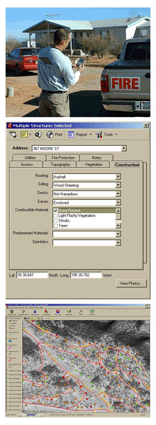
Platte Canyon Fire District is a high wildfire risk area, located southwest of Denver in the Front Range of Colorado. In the last five years it has been threatened by three devastating fires, including the Hi Meadow, Buffalo Creek, and Hayman Fires. Using the services of Anchor Point, a fire management consulting company, the Platte Canyon Fire Department conducted a house to house wildfire risk survey of 4,300 homes in October of 2003. They used Americorps volunteer crews and handheld computers equipped with RedZone Software. RedZone Software allowed the volunteers to enter individual house locations, pictures, and risk data directly into the Palm handheld computers, saving time in transferring data.
RedZone Software
RedZone Software brings GIS technology to the field for wildland fire prevention and suppression using three separate programs.
RZ Survey uses handhelds to collect specific information about structures, water sources, helicopter landing zones, fuels, fire stations, and other important information specific to the agency. Data is transferred directly to maps in a single step. Types of structure data which can be collected using the RedZone RZ Survey software includes:
- Construction materials � including the flammability of roofs, presence of open eaves, siding type and presence of combustible materials near house;
- Access issues � number of ingress/egress routes, length, width and clearance of driveways, availability of turnarounds, visible address, presence of gates;
- Surrounding fuels � including the presence of defensible space, predominant fuel type, aspect, slope, and presence of vegetation near roof;
- GPS coordinates;
- Digital photo;
- Location of water sources and type;
- Placement of gas and electric utilities;
- Specific mitigation actions recommended for the homeowner.
Using Palm Pilots, GPS units and digital cameras, it takes only about 5 minutes to complete an individual home assessment.
Using the RedZone Utilities software, data can be uploaded while surveyors are out in the field. The homes are automatically projected onto a map with subdivision roads, aerial photos or topographical maps as a background. All home information, including photos, is quickly accessible by selecting a home location on the map. Home locations are color-coded based on the hazard risk score of the property. Maps also show historical fire locations, water sources, and location of fire stations. Customized homeowner mitigation reports can be generated with specific action items to help jumpstart community education projects.
RedZone�s FireDirect allows initial attack firefighters to easily map fire perimeters. The report tools in RedZone's FireDirect allow firefighters to create reports for individual homes when a wildfire threatens. Maps of the threatened subdivisions can be generated for teams on location, with information on water source locations, spot fires, fire origins, closed roads, drop points, and safety zones.
John Pawlik, Wildfire Mitigation Officer for the Platte Canyon Fire District, described the RedZone Software as �simple to use�, and said that they plan on installing FireDirect in each of their engines so that home information is available to firefighters in the field.
Contact Information
For more information on Platte Canyon contact:
Jeff Davis or John Pawlik
P.O. Box 222
Bailey, CO 80421
303-838-5853
Or via email at:
[email protected]
[email protected]
For information on RedZone Software, contact Clark Woodward, at 303-386-3955, or see the RedZone Software website at www.redzonesoftware.com.
RZ Survey - Structure Hazard Assessments
|
|
Images: |
|
1. | 
|
|
|
|
|


