The national database of state and local wildfire hazard mitigation programs
serves as a clearinghouse of information about nonfederal policies and
programs that seek to reduce the risk of loss of life and property through
the reduction of hazardous fuels on private lands. If
you would like to submit a program to the national wildfire programs database,
please complete the following form (MS
Word).
Return to your search results or Perform a new search
|
Title: |
Boulder County, CO - Wildfire Hazard Classification
|
|
Type: |
Education
Designation of high risk areas
Community Planning
|
|
Jurisdiction: |
County
|
|
State: |
Colorado
|
|
Program Description: |
You may visit the website, Wildfire Hazard Mitigation for Boulder, CO, in it's entirety.
In 1990, under a mandate from the Federal Emergency Management Agency (FEMA), agencies and individuals involved in the Black Tiger Fire produced a report that formed the wildfire portion of the Colorado Natural Hazards Mitigation Plan.
That original group evolved into the Boulder County Wildfire Mitigation Group (BCWMG), chaired by staff in the County Land Use Department, and consisting of members from County Departments, County Fire Protection Districts, the Colorado State Forest Service, the City of Boulder, federal land management agencies, and private citizens. The group's mission was to determine and coordinate actions that could help minimize loss of life and property from future wildfires.
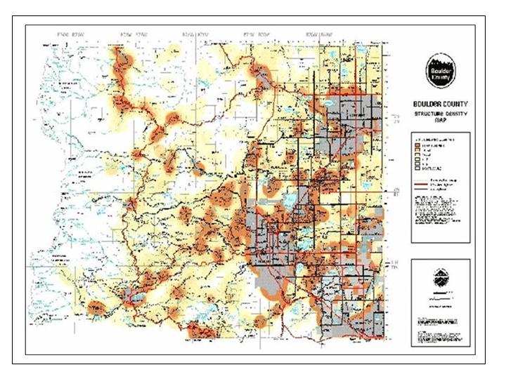
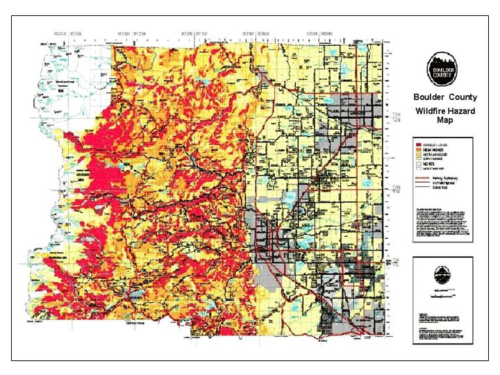
In 1992, a technical team from the BCWMG began designing and developing what is now referred to as the Wildfire Hazard Identification and Mitigation System (WHIMS). WHIMS strives to identify wildfire hazards, educate homeowners, assist land managers, and assess the risks involved due to wildfires. In addition, it aims to assist in pre-attack planning, emergency response planning, land use planning, and disaster assessment.
Goals and Objectives
- Using GIS as the medium, WHIMS is designed to:
- Collect site-specific fire hazard information
- Compile the information into a central database
- Display the information as various kinds of maps, tables, and other graphical outputs
- Get the information out to individuals to be used on the ground.
WHIMS
WHIMS combines wildfire hazard assessment, prevention, and suppression expertise, with fire and forest management knowledge using geographic data management and analysis techniques and technologies. WHIMS strives to:
- Identify local wildfire hazards and assess the risks to communities;
- Educate and motivate homeowners and private landowners and increase community involvement with wildfire awareness and preparation;
- Assist land managers and planners in making appropriate decisions about land management and development in fire prone areas;
- Assist local fire protection districts in pre-attack planning;
- Assist local emergency management and disaster relief agencies in with disaster assessment and emergency response.
- The overall goal is for the program to communicate information effectively to all interested parties and to ensure follow up with action programs. In order to accomplish this, community and interagency partnerships are a necessity.
Components
Data Collection, Input and Management
- Parcel Information - lot boundaries and ownership information extracted from the County Assessor's parcel ownership database.
- Terrain Data - topographic information extracted from USGS digital elevation model data (DEM).
- Vegetation Data - fuel type data was specifically mapped for the project.
WHIMS Wildfire Hazard Data
Questionnaire - developed with wildfire hazard experts. Site-specific hazard data are collected on-site using a hazard-rating questionnaire for each parcel. The questionnaire is filled out on-site by volunteer fire fighters involving personal contact with homeowners whenever possible. This allows the resident to ask questions and discuss the hazards and possible mitigation actions. In addition to educating homeowners during the site visit, the fire fighter becomes more familiar with his/her district. This direct contact, participation, and education opportunity is a key benefit of WHIMS.
Data Analysis � Hazard/Risk Assessment
Wildfire Behavior Modeling These are completed using a hazard-rating model based upon wildfire behavior models and the expertise of wildfire behavior specialists. An overall hazard rating and individual factor ratings, i.e., topography and fuels, construction, landscaping, defensible space, accessibility, water, and fire protection are produced. In addition, the mitigation potential through improved site maintenance or structure remodeling can easily be determined.
Information Dissemination
- Homeowners
- Local Fire Protection Districts & Departments
- Land Use Planners
- Emergency & Disaster Service Groups
- Forest & Resource Managers
Hazard and factor rating maps are provided to the fire protection districts for pre-attack and resource placement and planning. Information maps have been generated showing hazards and ratings both on a regional scale as well as a local scale (individual lots). The information is available to the public.
Wildfire Hazard Assessment
- Assessed using a hazard-rating model - WHINFOE
- Based upon the BEHAVE wildfire behavior model & the expert opinion of wildfire behavior specialists
- Overall hazard rating and individual factor ratings are produced
Database Maintenance
Efforts are currently underway to survey new areas and to resurvey areas first surveyed in 1995 to keep the system current. To date, most fire districts in Boulder County have completed or partially completed surveys.
Contact Information
For additional information please contact, via email: C.M. Hay, The Wildfire Interface Group, J.H. Korte, Boulder County Land Use Department, or Eric Philips, Wildfire Mitigation Coordinator.
|
|
Images: |
|
1. | 
|
|
|
|
2. | 
|
|
|
|
|


